Around the US district maps for congress and state legislatures have been drawn to further party power to the detriment of good representative government. This site is dedicated to Open Source tools and techniques for making that better.
BDistricting
What redistricting is and what it could be.
Results from 2010 Census are coming in!
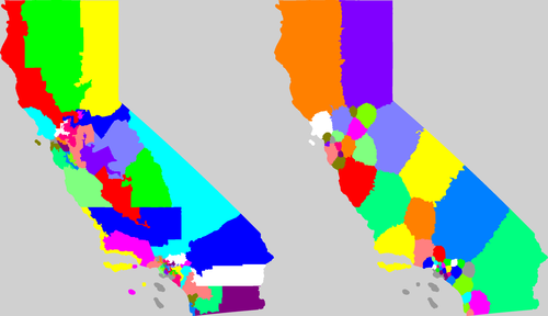
California:
Current congressional district map and a possible solution I generated. (click for more info and larger view)
BDistricting Blog
All solutions...
AL
AR
AZ
CA
CO
CT
FL
GA
HI
IA
ID
IL
IN
KS
KY
LA
MA
MD
ME
MI
MN
MO
MS
NC
NE
NH
NJ
NM
NV
NY
OH
OK
OR
PA
RI
SC
TN
TX
UT
VA
WA
WI
WV
What is a district for?
What is a good district?
Compactness Measures and Variations
Competitive districts
Voting Rights Act, Minorities
Amend the US Constitution
Other Redistricting Sites
Other Election Reform Issues
About the Author
Open Source
email me
This work is licensed under a
Creative Commons Attribution-Noncommercial 3.0 Unported License
.